Showing posts with label adventure racing. Show all posts

IT IS THE YEAR 2314. The city of Minneapolis is abandoned and covered in dust. Teams of explorers brave the harsh conditions to dig the ruins, searching for answers.

WHICH DEADLY PROBLEM RUINED THE CITY? This is the mystery you must solve.


This is the challenge that faced myself and six friends last weekend, near Minnehaha Falls in Minneapolis.  City of Dust was a bike adventure/puzzle/game put on by Northern Lights, a local arts agency.  They are best known for an all-night arts festival held along the river every summer, but this was the first other event of theirs I'd been to.

Adam, Kristen, and Elizabeth from my recent orienteering adventure reenlisted for City of Dust, and we were joined by Molly, Brenda, and Kelly, some other local climbers.  We would be tasked with discovering which of six serious environmental problems had caused the downfall of Minneapolis.  We'd figure it out by visiting five dig sites around the area, each excavating a different portion of the cities past.  When I signed us up, I didn't even know all that.  All I knew was that it was supposed to be a beautiful day, it involved bikes, and that I like games and puzzles.
At the start we were given our map, depicting a sort of post-apocalyptic version of the Minnehaha Creek/Lake Nokomis area.  It showed the five dig sites, and had a handy scrawled overlay to relate some important real-world locations to the game world.

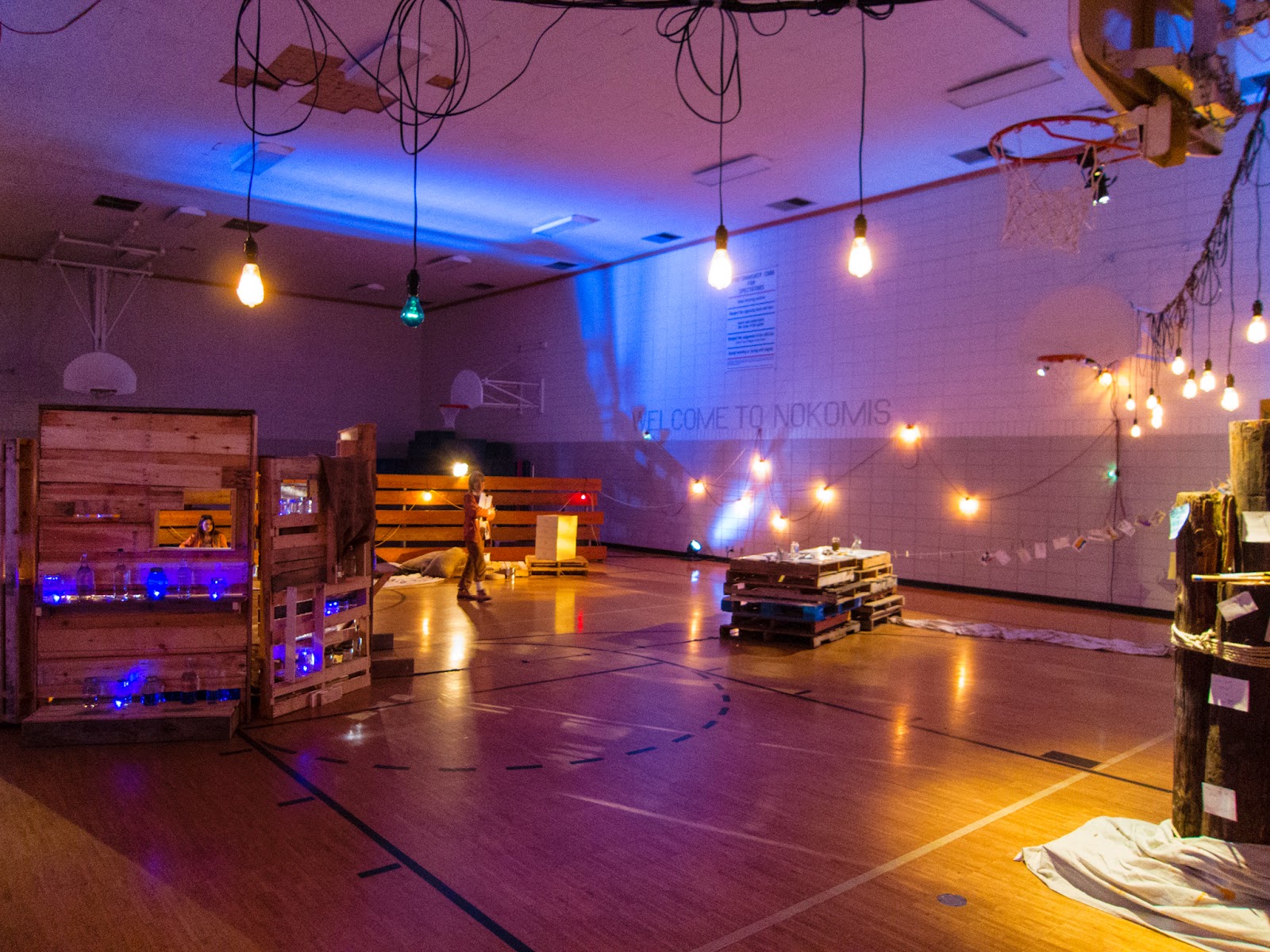
Our first stop wasn't far from the orientation.  At each location we'd watch a short video found by the excavators, each one depicting a resident of the time period in question.  The video would give us hints, helping us assemble a timeline of the various cataclysms that befell the area.  After we watched the video, there was a challenge to complete, which would net us some vials of pure water, and a vial unique to each era, full of water polluted with various materials.  After that we'd get an "echo trace", which was a small map with directions to a hidden artifact (depicted above).  The artifact would give us a code, which we could enter in to the echo trace hotline on a phone to get more clues.
The challenges at each dig site had great variety, although weren't ever very difficult.  My favorites were cleaning up a chemical spill (chasing bouncy balls around a tennis court with tongs and oven mitts), and navigating a power plant taken over by giant mutant dung beetles (using pool noodles to fend off giant balls representing dung balls of doom, with a time limit!).  Another awesome challenge had us all hopping in a "dust rover" (huge canoe courtesy of Wilderness Inquiry), paddling out into the "Nokomis dust basin" (Lake Nokomis) to try and count a floating mass of plastic bottles and bags.
After we'd visited our fifth site, we were rewarded with a new location added to our map (the blue dot in the 2nd picture of the post).  This would lead us to the undercity, if we were able to figure out which of the six deadlies had been unfixed, and was still affecting the city.  We entered a blue tent and met with two VERY stoic researcher-types, who asked us if we'd determined the cause.  We didn't have a CLUE!  We'd taken notes and debated a bunch on the timeline (although it didn't help that we got two of the videos at the wrong stops in time, which did confuse things a little), and we had 5 water samples, one from each point in time.  What we HADN'T done was pay attention to the colors of the pollutant beads in each sample...  
The scientists helped us out, graphing out the colors of each sample along the timeline.  When we figured out what environmental issue each color represented, that clued us in that the problem that hadn't been cured was the Rainsheet Drains (water runoff).  With that discovered, they gave us the secret knock we'd need to enter the haven deep underground.
Underground we were greeted by a sight like something out of the game Fallout, or the Walking Dead.  A small city had been constructed, around a well of pure clean water.  Here we could spend the vials we'd been awarded for various challenges to get advice, paint postcards, and sample honey or various spices.  We all shared a toast of water in celebration of our achievement.
All told the adventure took us about 4 hours, and we covered about 8 miles getting between the various dig sites (route and stats here).  At just $15 for our entire team, it was an inexpensive and fun way to spend a day enjoying the fall Minnesota weather with a bunch of friends.  I think that the people at Northern Lights did a great job putting on the event, and it managed to be a good time and also draw awareness to some of the biggest environmental concerns we're facing here in the Twin Cities.  The rest of the photos are below, I hope you enjoyed my little review/account, and will consider checking out Northern Lights to see what else they've got coming up!


Couldn't ask for a better day!

The chemical spill
In my ongoing quest to get myself to exercise, I frequently find activities that are very much LIKE running, but are not just going for a run.  After the Amazing Contenders tri, I'd been looking online for more excuses to get my heart rate up, and I somehow found the Minnesota Orienteering Club website.  Oddly enough, as a kid I did a couple of their meets with my parents and a friend or two, usually running around a state park, with a compass but usually just navigating by landmarks and the boundless energy of middle schoolers.  Since then I haven't orienteered at all, and have hardly used the compass I've got, usually forsaking it for the all-knowing GPS.  It just happened that their next event was taking place about 5 minutes from my apartment, so I put out the call on Facebook and quickly found three friends to fill out my team.
The Captains of Crush, from the left, Adam, Elizabth, Kristen, and myself
We showed up not really knowing what to expect, but found the MNOC regulars to be very friendly.  Living so close, I'm very familiar with the park the race was held in, which would serve us well considering the race started a little while after sundown.  We chose the long (6km) route, and the whole thing kicked off with a mass start.  Seeing as how I'm not a very fast runner, we quickly fell behind the faster runners, but with the excellent map, compass, and the occasional glimpse of another racer's headlamp in the distance we were able to keep from making any serious navigational mistakes.
Post-race, trying to figure out if we were using the compass right
It felt slow, but as we reached each control point in succession we were always neck and neck with at least a couple teams, so I was hopeful that we would at least not be last!  As we headed to the final point, we realized we were on the wrong side of some woods, and made the decision to cut through, hopefully saving a significant amount of time.  As soon as we stepped a couple of feet off the sidewalk, it was apparent that it would not be as quick as we'd hoped.  The spaces between trees were just choked with thornbushes, and it was easy to track our progress through them by the chorus of curses as we picked up new scrapes and cuts.  Myself and Adam made it through, and found the control point, so I took off for the finish just about 100m away, trying to catch up to another racer just ahead.  I did it, but turned around to find Adam had disappeared back into the brush to lead Elizabeth and Kristen out.  Such a gentleman, but it cost us valuable seconds!  Luckily, even with the delay we ended up 15th out of at least 18, achieving my goal of not being last!
After the race, we adjourned to a nearby bar for drinks and food with the other racers, where we learned a bunch more about the MNOC, discovered there's such a thing as mountain bike orienteering, and learned of this crazy orienteering stats thing called Attackpoint.  Coolest name ever, right?  I'm already signed up for the next Adventure Race on the 30th, and will definitely be checking out other local orienteering events.  If you've never done one, I recommend you search for a club in your area. Even if you're brand new, they'll usually loan or rent you a compass, and probably can even show you how to use it if you ask nicely.  You'll learn some  usefull skills and get a great workout!  If you want to see our route, it's on Strava here.  Don't laugh at my pace...  Our Attackpoint stats are here, and that will show you our splits for each control point and how we compared to the rest of the field.  I have no idea what some of the other numbers mean yet!